
It’s a practice that has taken place for over a century, people across Great Britain have grabbed Ordnance Survey (OS) maps, unfolded them and then scanned across the beloved grid squares searching out the familiar symbols we all learnt in school – roads, rivers, woods, churches, youth hostels, trig points, train stations, parking, contour lines etc.
All of this detail is vital to help you plan your next adventure and to navigate on the day – Where are you going to park? What feature are you going to take a bearing off? Where might you stop for a spot of lunch?

Have you ever stopped to think about how all this detail gets onto the map in the first place and more importantly how does it get updated? I spent a day and a half with Dom Turnor, a Surveyor with the OS, finding out how the master map of Great Britain is updated and how often. I make no apologies for the length of this post as I believe it is deserved given the subject matter and the privileged access given to me by OS.
Dom is one of approximately 250 field surveyors across the country and is responsible for the Malvern District, which is part of the Wales and West Central region. His district is long and thin from the county borders of Worcestershire and Shropshire in the north, down to Cheltenham in the south, as highlighted in the image below.

Due to the size and shape of the District, Dom plans his work into economic packages, saving time, fuel and the environment. I joined him for this planning on Monday afternoon at his home office where he explained the systems, processes and different types of surveying tasks he undertakes on a daily basis.
You may be surprised to learn that OS make approximately 10,000 changes to the master map every day and aim to capture all major change within 6 months of it happening. Each of these changes start as a field customer order which are generated from numerous sources such as HM Land Registry, Local Councils, Surveyors, OS HQ, third party suppliers etc. Whilst there are multiple categories for these orders the majority will fall into one of four categories: –
- Prestige sites – Sporting venues, Large shopping centres.
- Land Registry – Survey requisitions for boundaries and land access
- Total Revision – Changes such as construction works, house building
- Derived Products – The symbols identifying locations and services
The field customer orders are downloaded on a regular basis to the surveyors computer and then “taken-up” to show that a surveyor is assigned to the order. As I would be spending the following day with Dom, he had selected a range of orders from the various categories, with the exception of the Prestige Sites as these are generally complex by nature. For example the redevelopment of the racecourse in Cheltenham took several full days to survey.
Our customer orders for the following day were: –
- Land Registry – boundary survey between two private properties requested by HM Land Registry so that the deeds to the properties could be updated.
- Total Revision – a new Sainsbury’s Local supermarket has recently been built and opened in Malvern. The store and surrounding area needs to be surveyed and added to the master map.
- Land Registry – query over the precise location and boundaries of an electric sub station in Malvern.
- Total Revision – several new housing estates and notifications of potential building works in the Malvern area. These would be initial visits to ascertain the stage of the building works, if any.
- Derived Products – a selection of locations and services that we would check were still there as we were passing them.
I met Dom on the Tuesday morning and after a few admin tasks we set off for the first land registry job, as it relates to private property I won’t go into much detail, albeit to say that we met the land owners, surveyed the fence line and boundary identified in the request, along with several photographs from requested viewpoints.
With the land registry job complete, we headed off for the new Sainsbury’s Local in Buttercup Walk, Malvern.
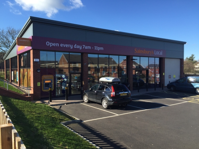
I was surprised and delighted when Dom said that he would let me survey the store! As you can see from the photo above, the store is essentially a rectangular box, with a car park, several fences and landscaped areas.
With the wide open space this is an ideal area to use GPS, the Global Positioning System – a network of satellites in a precise orbit constantly transmitting signals to Earth. Essentially a GPS receiver compares the time a signal was transmitted by a satellite with the time it is received, it is this time difference between the signals that tells the GPS receiver how far away the satellite is. Once the receiver picks up more than three signals it can start to triangulate its position, the more satellites it picks up the more precise the location will be. The OS has a beginners guide to GPS if you would like more detail.
Most of us are probably familiar with GPS receivers and have used one in some form or another, with receivers in sat navs, smartphones, activity tracking devices and handheld navigation devices. These devices are generally accurate to within 5 to 10 metres 95% of the time. Whilst this level of accuracy is sufficient for consumer use, it is not precise enough for detailed mapping. Therefore, each OS Surveyor has a state of the art Leica GS15 GPS receiver, mounted on a 1.8 metre pole and connected to the surveyors laptop via bluetooth and to the cellular phone network.

With the equipment setup and connected Dom handed it over to me, I planted the GPS pole on the first corner of the car park, ensured it was level, waited for it to acquire the satellites (we managed to receive signals from 14 satellites), I watched the accuracy/quality of the signal improve to 0.01 (I believe that means an accuracy of 1cm!) and clicked on measure. A dot appeared at our location on the map, we moved on to the next corner, waited for the accuracy to be less than 0.10, click another dot, then a line appeared joining the dots, move to the next corner, click, another dot, and so on until we had the complete outline of the car park. Next came the curved kerbs of the entrance to the car park, selecting the curved line tool I measured several points around the kerbs. Next up was the fencing and footpaths around the site. With all the landscaping and ground work complete it was time to survey and plot the buildings location.
To get an accurate location with GPS the receiver needs a clear view of the sky, up until this point we were getting very accurate measurements, as we went closer to the walls of the building the accuracy dropped to an unacceptable level. Therefore to obtain the locations of each corner, we measured a point along the line of each wall, as close as possible with an acceptable accuracy level. When you have six of these measurements (two at each of three corners) you can join the survey points with lines (the same as plotting the kerb line of the car park), these lines will intersect at each of the four corners giving you the outline of the building. At this point we had a complete plan of the area made up of multiple polygons on the map.
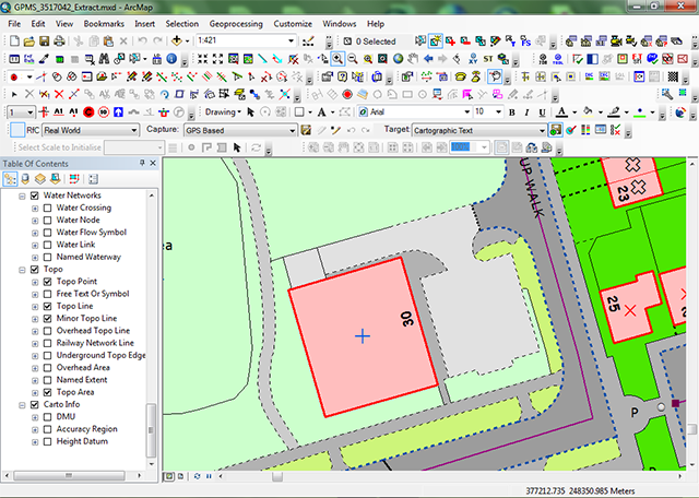
The next stage is to attribute each of these polygons to define what it actually is, this does not need to be done on site. As it was approaching midday, we decided on an early working lunch somewhere in the warm.
With a steak and stilton baguette in hand and a warming mug of coffee, we fired up the laptop and started to attribute the polygons we had plotted. This is where detail is important, for example a path isn’t the same as a pavement (a pavement is on the side of the road, whereas a path goes through an open area), next is the surface sealed or unsealed? likewise a verge can only be used for the side of a public road and not the edge of a car park. The last attribute to assign is to set the Sainsbury’s building as a functional site (retail) and add the road number to it. The number on the building must be aligned to the road it is on. The image below shows the final result of our survey.
Having eaten and warmed up, with went off in search of the Old Hollow electrical sub station. The sub station is located up a small dirt track surrounded by tall trees, we attempted to get a GPS location, but as expected the accuracy was out by over three metres due to the trees. Without GPS it was back to the trusty tape measure, line of sight and measuring from other features already plotted on the map.

Next on our list were several sites that have been marked for new construction works. There were no signs of any work on any of these three sites. However, this isn’t unusual as planning permission can be granted but the developers do not necessarily start immediately. Although we did locate two new housing estates being built in Welland. It is important to keep on top of these sites, especially new housing estates as it is quicker and easier to survey a buildings foundation with accurate GPS signals before the walls are built.
Last on the list were several Derived Products, these are the familiar symbols across the map, we didn’t get the opportunity to check many of these as surveying the sub station took longer than expected. A viewpoint, such as the Worcestershire Beacon on top of the Malvern Hills, is extremely unlikely to change. However, items such as telephone boxes are being decommissioned and removed on a regular basis. Although most are removed they are also being re-roled for other purposes, such as housing defibrillators or in the case of one in Malvern, a library/book exchange. Therefore just driving past a telephone box isn’t enough to check that it is still in use.
Having finished the field surveying, we returned to Dom’s house to fill out the paperwork for the land registry surveys, upload our changes to the main OS servers in Southampton and submit the completed field customers orders and paperwork.
I’m now going to be checking the online OS Maps and iPhone OS Maps app daily looking for these changes to appear. I can now officially say “I’ve put Sainsbury’s on the map”
I can’t thank Dom and the Ordnance Survey enough for showing me a peek behind the scenes, there is so much more detail that I could have added but I wanted to keep it to an overview of the day. I hope that this post gives you an insight into the role of a OS Surveyor and that you found it as informative and enjoyable as I have researching it and writing it.
I am now wishing that I asked to do this for work experience back at school and a pursued a full time career as a Surveyor…

Very interesting Dan. I was going to ask if it was a job interview! Forgot about work experience! I love maps but had never stopped to think how places got mapped. Probably thought someone had to sit down and draw it. I expect they did 60 years ago when I was at school learning map signs etc. If you need any old O S maps, I have some hidden away upstairs!
Love Mum X. 🚗☕️✂️😀
>
LikeLiked by 1 person
Yes they were originally drawn by hand, the BBC did an interesting programme about it. Its not currently on iplayer, although there is a clip available at http://www.bbc.co.uk/programmes/p031gxhw
LikeLike
Great article thanks for sharing, Amelia and I both chuckled at the “now I’ve put Sainsburys on the map” comment. Andy 🐾🐾xx
LikeLiked by 1 person
Very informative article. I could see you had enjoyed your day and you have told me some very interesting things about how OS maps work. I don’t think people realise how much work goes into the maps.
LikeLiked by 1 person
That was really interesting Dan – methinks a change of career is beckoning!
LikeLiked by 1 person
I think I missed by vocation…
LikeLike
Pingback: Above the scenes with Ordnance Survey – Coeur Cycliste