Ordnance Survey Flying Unit

Above the scenes with Ordnance Survey

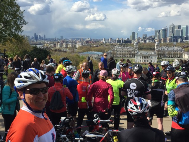
Back in February I went behind the scenes at Ordnance Survey with Dom Turnor, a Field Surveyor at OS, to find out how the master map of Great Britain is updated. During the day I discovered that there are areas that cannot easily be surveyed on the ground, this can be for a variety of reasons including the size/nature of the site, access restrictions or the safety of the surveyor. In these situations the changes can be surveyed using aerial photography. Ordnance Survey have had a dedicated Flying Unit since 1966. OS used aerial photography prior to this and had operators of it’s own, however it was shared with the Royal Air Force and other government departments.

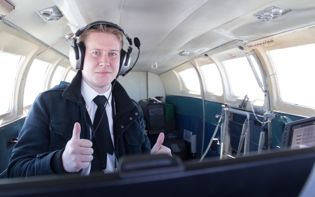
I met up with Air Camera Operator and Field Surveyor Roger Nock at East Midlands Airport to find out more about the Flying Unit and how they capture the aerial imagery required to update the master map.

Ordnance Survey Cessna 404 / G-FIFA

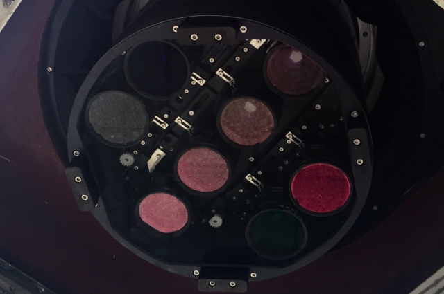
Ordnance Survey have several planes, each equipped with a large format digital aerial camera system by Vexcel Imaging. This is a state of the art UltraCam digital camera, consisting of eight lenses and 196 megapixels.

The camera/sensor unit is mounted behind the camera operators seat with the airborne computing unit, removable data storage and interface panel to the operators left. The pilot has a secondary display screen which can be mounted to the instrument panel whilst imagery is being captured.

G-TASK Inside

IMG_5628-2

Mounted in front of the camera operator is a forward looking scope for a detailed view of the area and terrain ahead of the aircraft.

Image through the Air Camera Operators scope - Photo by Ordnance Survey
Image taken through the Air Camera Operators scope – Photo by Roger Nock / Ordnance Survey

The flying season is between late February and early November and is very much dependent on the weather, air traffic control and permission to enter areas of restricted airspace.

Not only do they have to factor in the infamous UK weather, our airspace is also one of the busiest in the Europe, if not the world, especially in the South East with the shear volume of arrivals and departures into the main London airports. In 2014, London Heathrow handled 73.4 million passengers during 470,695 aircraft movements, an average of 1290 flights a day (data from LHR Airports Ltd).

Everything needs to be in place for a flight to take place. The weather needs to be favourable, rain and clouds in the target area will cast shadows on the imagery or completely obscure the ground. Permissions from multiple air traffic controllers along the flightpath and permissions to enter restricted flight areas need to be obtained, the pilots total flying hours that day also needs to be considered, not just total flown so far but the planned flying hours for the sortie need to be taken into consideration and of course the serviceability of the aircraft itself. However, before any of this can take place the flight needs to be planned, which starts with a request for a target to be flown. These can come from various sources including, field surveyors, OS HQ etc.

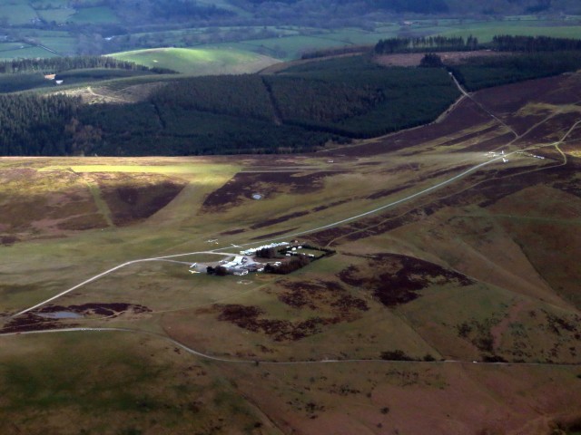
One target request that needed planning whilst I was visiting was for the Glaslyn river estuary in North Wales, this estuary is predominately sand banks and needs to be accurately surveyed in order to update the master map. As you can imagine this task just isn’t feasible for a ground field surveyor to undertake.

Afon Glaslyn / Traeth Mawr
Afon Glaslyn Estuary – Crown Copyright Ordnance Survey

With the target site identified, the air camera operator checks the Civil Aviation Authority (CAA) airspace charts for the location and any flying restrictions/hazardous areas.  The majority of North Wales is free airspace, however there a few restricted areas with an RAF airfield on Anglesey and some of the valleys being used for low level fast jet training. In our case the Glaslyn estuary is in the free airspace, so there are no restrictions or additional permissions required.

Flight Planning in the OS Flying Unit

Aerial imagery is captured by flying at a set speed and altitude in a straight line with a photo being taken approximately every 3 seconds (depending on speed).

Having entered certain details into the computer, such as Camera Type, Ground Sample Distance (GSD is the distance between the pixels on the image measured on the ground eg. in an image with a one metre GSD, adjacent pixels image locations are 1 metre apart on the ground).

The operator can then draw the flying strips onto the target area, these appear as black rectangles with the blue centre line being the flightpath of the aircraft and the red dots indicate the location an image will be captured. In order to obtain the best quality survey the images are overlapped, generally by 30%. Additional strips are added until the target area is completely covered as shown in the screenshot below.

Whilst the location of each photo is captured with GPS it is good practice to include several map features in the imagery, such as a main road or village centre, so that the newly acquired imagery can be aligned with existing map data. The original target area is the black outlined polygon just visible under the main rectangles.

OS Flight Planning

In order to fully survey the estuary OS will need to fly five lines capturing a total of 144 images, with each line being flown at 5,800 feet and 175 knots. This relatively small target area will take approximately 30 to 35 minutes to survey when you add in the time it takes to turn the plane at the end of each line. In this example the altitude of each line remains constant as the terrain is flat, in more hilly areas the altitude of each line needs to be adjusted in line with the terrain so that the GSD remains constant as well. An additional element for this sortie is that it must be flown at low tide thereby adding to the complex of scheduling it.

The weather had been poor in the morning of my visit and just when it was looking like we wouldn’t get to fly at all, there was a break in the weather over South Wales and we would be able to fly a sortie. The selected target in Aberporth was a single line which would take five minutes to survey at an altitude of 5800 feet.  During the week the area is restricted airspace and even though it was a Saturday permission would still be required to fly in the area.

Aberporth Flying Danger Zone
CAA Airchart / Aberporth Danger Zone – Crown Copyright Ordnance Survey

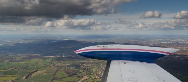
Our pilot for the day Liam Watt had called ahead and with permission granted, the surveying systems setup and configured we took to the skies over East Midlands and set course for Cardigan.

IMG_7747

The outbound flight took us out towards Ironbridge, south of the Wrekin and then over the Shropshire Hills and the Welsh Marches.

IMG_7780
Outbound flight over Ironbridge, Shropshire

IMG_7782

We had to be extra vigilant in this area by keeping an eye out for gliders, due to the number of clubs in the area and the weather was perfect for the gliders to soar on the thermals, their small size makes them difficult to see.

Long Mynd Gliding Club
Midland Gliding Club, Long Mynd – Photo by Roger Nock
IMG_7794
Banking over the Welsh Coast approaching the target line

As we approached the target area, I heard Liam say to Roger over the intercom  “cloud on the line”, this potentially meant we would have to abort the sortie and return to East Midlands without any images. Fortunately as we turned for the line it was in fact clear and Roger started capturing the imagery.

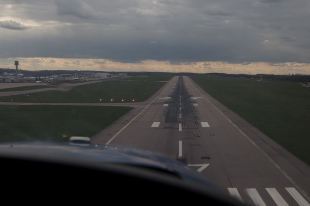
From the co-pilots seat I watched Liam’s secondary screen on the instrument panel in front of me.  The images below shows: Top Left – approaching the line.  Right – flying the line. Bottom Left – Line complete and turning back for East Midlands.

Flying the Line

Roger Nock - Line Complete

Roger was happy with the images he captured and with the survey complete we turned for the return flight over the Welsh Marches and the Shropshire Hills back to East Midlands airport.

IMG_7802

Landing at East Midlands
Ordnance Survey Cessna 402 - G-NOSE
Ordnance Survey Cessna 402 – G-NOSE

Having landed and taxied back to the hanger, the last remaining tasks are to remove the data storage units from the aircraft and copy the imagery from the aircraft systems onto the servers where they will be sent to OS in Southampton for processing and updates to the master map will be made.

I would like to thank Ordnance Survey and especially Roger and Liam for giving me access to the Flying Unit for what was a fantastic experience and truly a once in a lifetime opportunity.

London to Paris 24 Hour Sportive – Stage Two, France

My London to Paris adventure continued from my previous post …

Stage 2 – Dieppe to Paris

Having taken advantage of a late offer of a berth in a cabin I managed to get some sleep, although I’d been asleep for what felt like a few minutes before the ferry’s PA system was announcing that we would shortly be docking in Dieppe – in reality I probably got about four hours sleep.

For some reason the ferry had docked an hour late into Dieppe, so we were behind schedule, unperturbed by the delay we disembarked and left the port to meet up for a quick snack and a rider briefing.

London 2 Paris 24hr cycle sportive. Photo credit : Chris Winter
Riding off the ferry at Dieppe – Photo by Chris Winter

I had checked the weather forecast for Sunday before I left Greenwich, at that point it was saying 6 degrees for Dieppe at 5am and the late teens early twenties for Paris in the afternoon, so I had already decided on shorts. However, the clear skies overnight had made the temperature plummet and my Garmin was reading zero degrees celsius as I rode off the ferry – guess who couldn’t find his long fingered gloves…

London 2 Paris 24hr cycle sportive. Photo credit : Chris Winter
Rider briefing and quick snack in Dieppe – Photo by Chris Winter

After a quick banana and a handful of Haribo, we were a rolling peloton of fifty riders. I restarted my Garmin at 5:38am (French Time) and a long line of flashing white and red lights started to string out illuminating the sleeping port of Dieppe.

London 2 Paris 24hr cycle sportive. Photo credit : Chris Winter
Heading off into the French countryside – Photo by Chris Winter

Next stop breakfast at Buchy in 30 miles.

There was something magical about cycling through the night and the villages of northern France. The boulangeries and pâtisseries were the only buildings lit up, each spilling out a welcoming glow of warmth onto the roadside, the smells of their wares and freshly baking bread wafting out over the road enticing me to stop… as alluring and seductive as it was I stayed faithful to the road and didn’t stop, instead the smells urged me onwards towards the town of Buchy for our planned breakfast stop. However, I must one day return to try a freshly baked croissants and perhaps un Pain et Baguette Normande.

With each revolution of the pedals the black starry night sky slowly gave way to the first signs of dawn as the sun rejoined us for our epic adventure to Paris. The sun and its warmth were very much welcomed and it wasn’t long before my fingers started to thaw and the feeling returned to my fingertips, I might have been freezing cold but I was loving it. The cold temperatures had resulted in a fine mist rising off the rivers and lakes along the roadsides adding to the magic.

London 2 Paris 24hr cycle sportive. Photo credit : Chris Winter
Sunrise – Photo by Chris Winter

Breakfast in Buchy was a generous spread of items including ham and cheese baguettes, porridge, pastries, orange juice, tea and coffee.  The only sun in Buchy at that time of the morning was a strip down the middle of the road, as a result a large number of us where gathered around the traffic island getting strange looks from the locals as they pulled up at the junction.

London 2 Paris 24hr cycle sportive. Photo credit : Chris Winter
Breakfast in Buchy – Photo by Chris Winter

Suitably thawed, fed and refreshed it was time to make a move and continue onto Paris.  Just as I was about to set off, Matt (one of the group of seven other riders from Saturday evening) came over and said he was getting the band back together and we should head out together as a group of eight. We didn’t know it at the time, but it was at that point Team Tally Ho formed up and that we would stay together all the way to Paris.

London 2 Paris 24hr cycle sportive. Photo credit : Chris Winter
Team Tally Ho climbing up out of the mist after breakfast – Photo by Chris Winter

The early morning mist had been burnt away by the sun and with the temperature rising additional layers of clothing were being removed and stored away in jersey pockets.

Riding in the group was making the miles fly by, I managed to get a quick selfie and tweeted it to update family and friends back home of my progress (and to mention how nice the weather was!).

A quick selfie and tweet to update family and friends

Shortly after we rode into the town of Les Andelys and standing high on the chalk cliffs at the far end of the town was the impressive Château Gaillard, the ruins of Richard the Lionheart’s castle that he built in the late 12th century. I’ve had an interest in castles since I was a child so yet another reason for a more leisurely return to the area.

Chateau Gaillard

The town of Les Andelys is on the banks of the river Seine and it was here that we stopped for a snack with the chance to offload the now unneeded layers of clothing into our bags and another group photo, this time in our excellent L2P24 jerseys.

London 2 Paris 24hr cycle sportive. Photo credit : Chris Winter
Group photo on the banks of the Seine at Les Andelys – Photo by Chris Winter

What you can’t see in the photo above is the blood running down my left leg, as I arrived at the stop my cleat got caught in the pedal (my excuse and I’m sticking to it as I am sure that I unclipped), with both feet clipped to the pedals and no forward motion theres only one direction left to go… yes I met the ground coming up on my lefthand side, my knee took the brunt of the fall. Now usually the blood of a small cut and graze will clot quite quickly. However, with my heart medication my blood doesn’t clot very easily (and I don’t want it too either) so it was it time to test the first aid supplies and ask for a plaster.

With my knee patched up we left Les Andelys behind us following the meandering river Seine towards Vernon and ultimately Paris. With the quiet country roads we were riding two abreast for most of the way, the traffic was starting to build as we passed through Vernon so we took to a single file train taking turns at the front. I took the opportunity to record a short video of us as I dropped back from my turn at the front.

We stayed in the train all the way to the next snack stop, along the way Chris, Tom and Luke (the event photographers) passed us in the car. A couple of miles down the road I spotted the car parked on the roadside and they had setup on both sides of the road to take photos and video footage. I must say a big thank you to them all for the brilliant photos and memories.

L2P24-00-09-42-619
Chris, Tom and Luke setting up for a shot of the Team Tally Ho train
London 2 Paris 24hr cycle sportive. Photo credit : Chris Winter
The Team Tally Ho train to Paris – Photo by Chris Winter
London 2 Paris 24hr cycle sportive. Photo credit : Chris Winter
Snack stop 3 at La Roche Guyon – Photo by Chris Winter
London 2 Paris 24hr cycle sportive. Photo credit : Chris Winter
Clea taking a Tally Ho group selfie – Photo by Chris Winter

The section between snack stop 3 and lunch, whilst only 21 miles, had the two largest climbs of the day at Sailly and L’Hautil (almost 1200 feet in little under 12 miles), whilst climbing L’Hautil my Garmin clicked over onto 100 miles. By this time I could feel the previous 158 miles in my legs but I made it up both to be rewarded with lunch at Chanteloup Les Vignes.

Clea had completed the last part of the climb and into the lunch stop pedalling with just one leg as her lefthand crank had fallen off, fortunately the event mechanics weren’t far behind us and it wasn’t long until the crank had been reattached. We were on a way for the leg and the run into Paris.

We were getting close to the 24 hours and the traffic lights of the suburbs of Paris were not playing, each one seemed to turn red just as we approached. We crossed the Seine for the final time as a group and cycled under the Eiffel Tower, stopping my Garmin at 4:57pm (French time) – Total time 24 hours 28 minutes and if you allow for the ferry delay it would have been 23 hours 28 minutes.

L2P24-00-11-08-982
Crossing the Seine and arriving at the Eiffel Tower
London 2 Paris 24hr cycle sportive. Photo credit : Chris Winter
Champagne under the Eiffel Tower, Paris – Photo by Chris Winter

Whilst my goal was to cycle under 24 hours, I do not see it as a failure in a way, but a fantastic achievement for someone who has previously suffered a heart attack and couldn’t walk for more than 5 minutes without getting out of breath. If you would have said to me five years ago, as I was lying on my hospital bed on the day of my heart attack, that I would ride to Paris in 24 and a half hours I wouldn’t have believed you. It just goes to show what you can achieve, start off with small steps and see where it takes you, the most important thing is that you start.

So you’ve read about my experience, I hope you enjoyed it and that I’ve inspired you to want to do the same. If so sign up here for the ride of a lifetime and achieve something extraordinary.

It would be great if you could visit my Just Giving page and perhaps give a donation to Pumping Marvellous as we need to raise awareness about Heart Failure and help other heart patients that are not as fortunate as me.

I’ll be on the start line again in Greenwich on Saturday 29th April 2017 – I’ve still got that magic 24 hours to beat 🙂

Hopefully I will see you there and as Sophie says

One Day I Will Not Be Able To Do This, Today Is Not That Day

L2P24

London to Paris 24 Hour Sportive – Stage One, England

What did you do for the Bank Holiday weekend? I joined 49 other cyclists for the adventure of a lifetime by cycling from London to Paris in just 24 hours, just over five years to the day after my heart attack and raising funds for the Pumping Marvellous foundation. I had entered the London to Paris 24 hour sportive organised by Sophie Radcliffe and the team at Cycling Friendly.

The adventure began at the Royal Observatory in Greenwich Park. I had arrived an hour early, having cycled there from a local hotel that I had stayed at the night before. I wasn’t expecting the view from the start, as I reached a statue at the end of a tree lined avenue the view opened up to a one hundred and eighty degree panorama of the park and London beyond, topped off with the skyscrapers of Central London and Canary Wharf on the horizon – I’d only just arrived and the views were fantastic!

L2P24
London and Canary Wharf Skyline from the Royal Observatory, Greenwich

Other riders started to arrive and soon a small group had started to form around the benches opposite a van selling coffee. I was a little worried as I entered by myself and therefore would not know anyone, I needn’t have worried as everyone was extremely friendly. Introductions were being made along with the normal questions in this type of scenario, such as have you travelled far to get here etc?

London 2 Paris 24hr cycle sportive. Photo credit : Chris Winter
Riders arriving in Greenwich – Photo by Chris Winter

The record distance travelled goes to Milton, he had flown into London the day before from Brisbane, Australia just for this ride and another rider had come from America. It was turning out to be a truly international event before a pedal had even been turned. With the introductions, registration and rider briefing complete it was time for the official group photo in front of the iconic Canary Wharf skyline before heading off on stage one and the ferry at Newhaven.

Rider briefing at the Royal Observatory, Greenwich, London
Rider briefing at the Royal Observatory, Greenwich
London 2 Paris 24hr cycle sportive. Photo credit : Chris Winter
Riders of the 2016 London to Paris 24hr Sportive – Photo by Chris Winter

Stage 1 – London to Newhaven (58 miles / 93 km)

With the riders all assembled we set off for Paris, I started my Garmin at 3:29 pm (UK time) making the goal for the Eiffel Tower 4:29pm (French Time).

London 2 Paris 24hr cycle sportive. Photo credit : Chris Winter
Starting the adventure of a lifetime, Greenwich Park. Photo by Chris Winter

The busy streets of London were soon replaced with quiet country lanes as we made our way out of the capital towards Orpington, by chance the route passed my sister-in-law’s mother’s house and they had very kindly made a banner for me, encouraging me up the first main climb of the day.

Val and Ken's Banner
Val and Ken’s Banner
London 2 Paris 24hr cycle sportive. Photo credit : Chris Winter
Hawley’s Corner before the descent into Westerham – Photo by Chris Winter

After Westerham, the route climbed up onto the High Weald skirting Five Hundred Acre Wood, the scenery and views across East Sussex were stunning.

IMG_6425
Riding with Sophie over the High Weald in East Sussex. Photo by Sophie Radcliffe

I had hired a small GPS tracker for the ride from Open Tracking, this was sending my current position to a website every ninety seconds and displaying it on a map of the route for family and friends to track my progress. For UK based events Open Tracking use the detailed 1:25000 Ordnance Survey mapping, however as my event left the UK I had to use an alternative mapping partner.

Pumping Marvellous, the heart charity I was cycling in aid of, had also tweeted the tracking link to it’s followers before the start and was tweeting updates along the way, each one was appearing as a notification on my bar mounted Garmin. This was providing me with an excellent source of encouragement, knowing that others were following and supporting me along the way.

Screen Shot 2016-05-05 at 12.56.25

By this stage I had been cycling with a group of seven other similar paced riders and we were making steady progress towards our final stop of the evening. The sun was getting low in the sky, as it dipped behind the clouds and the horizon to leave us for the night we were rewarded with a fantastic sunset, unfortunately the photo below does not do it justice.

The setting sun on the approach to Newhaven
Sunset in Newhaven

We arrived in Newhaven at 8:11pm, having covered the 58 miles at an average speed of 13.5 mph with 3,570 feet of climbing, to be rewarded with a two course meal and the opportunity for drinks in a local hotel before riding to the ferry at 9:30pm. Whilst waiting to board the ferry I got talking to a couple of French cyclists who were on their return leg having cycled from Paris to London, on mountain bikes and mainly off road by the sounds of it – Chapeau!

Continued on the side of the channel in the next post