London to Paris 24 Hour Sportive – Stage Two, France

My London to Paris adventure continued from my previous post …

Stage 2 – Dieppe to Paris

Having taken advantage of a late offer of a berth in a cabin I managed to get some sleep, although I’d been asleep for what felt like a few minutes before the ferry’s PA system was announcing that we would shortly be docking in Dieppe – in reality I probably got about four hours sleep.

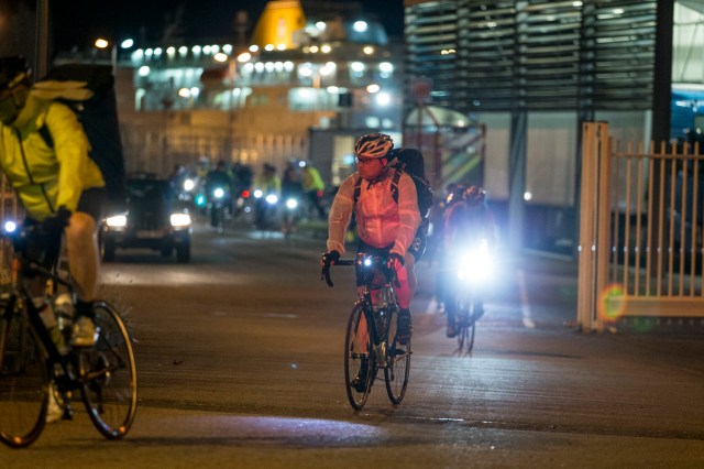
For some reason the ferry had docked an hour late into Dieppe, so we were behind schedule, unperturbed by the delay we disembarked and left the port to meet up for a quick snack and a rider briefing.

London 2 Paris 24hr cycle sportive. Photo credit : Chris Winter
Riding off the ferry at Dieppe – Photo by Chris Winter

I had checked the weather forecast for Sunday before I left Greenwich, at that point it was saying 6 degrees for Dieppe at 5am and the late teens early twenties for Paris in the afternoon, so I had already decided on shorts. However, the clear skies overnight had made the temperature plummet and my Garmin was reading zero degrees celsius as I rode off the ferry – guess who couldn’t find his long fingered gloves…

London 2 Paris 24hr cycle sportive. Photo credit : Chris Winter
Rider briefing and quick snack in Dieppe – Photo by Chris Winter

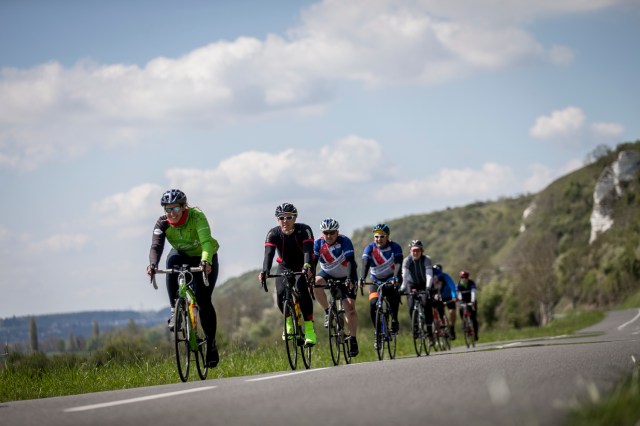
After a quick banana and a handful of Haribo, we were a rolling peloton of fifty riders. I restarted my Garmin at 5:38am (French Time) and a long line of flashing white and red lights started to string out illuminating the sleeping port of Dieppe.

London 2 Paris 24hr cycle sportive. Photo credit : Chris Winter
Heading off into the French countryside – Photo by Chris Winter

Next stop breakfast at Buchy in 30 miles.

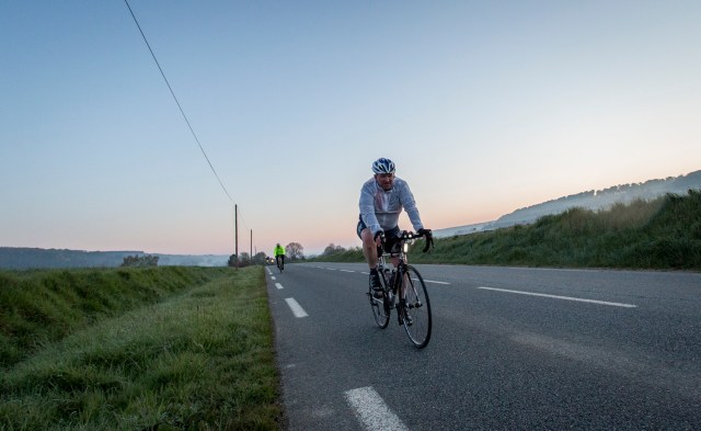
There was something magical about cycling through the night and the villages of northern France. The boulangeries and pâtisseries were the only buildings lit up, each spilling out a welcoming glow of warmth onto the roadside, the smells of their wares and freshly baking bread wafting out over the road enticing me to stop… as alluring and seductive as it was I stayed faithful to the road and didn’t stop, instead the smells urged me onwards towards the town of Buchy for our planned breakfast stop. However, I must one day return to try a freshly baked croissants and perhaps un Pain et Baguette Normande.

With each revolution of the pedals the black starry night sky slowly gave way to the first signs of dawn as the sun rejoined us for our epic adventure to Paris. The sun and its warmth were very much welcomed and it wasn’t long before my fingers started to thaw and the feeling returned to my fingertips, I might have been freezing cold but I was loving it. The cold temperatures had resulted in a fine mist rising off the rivers and lakes along the roadsides adding to the magic.

London 2 Paris 24hr cycle sportive. Photo credit : Chris Winter
Sunrise – Photo by Chris Winter

Breakfast in Buchy was a generous spread of items including ham and cheese baguettes, porridge, pastries, orange juice, tea and coffee.  The only sun in Buchy at that time of the morning was a strip down the middle of the road, as a result a large number of us where gathered around the traffic island getting strange looks from the locals as they pulled up at the junction.

London 2 Paris 24hr cycle sportive. Photo credit : Chris Winter
Breakfast in Buchy – Photo by Chris Winter

Suitably thawed, fed and refreshed it was time to make a move and continue onto Paris.  Just as I was about to set off, Matt (one of the group of seven other riders from Saturday evening) came over and said he was getting the band back together and we should head out together as a group of eight. We didn’t know it at the time, but it was at that point Team Tally Ho formed up and that we would stay together all the way to Paris.

London 2 Paris 24hr cycle sportive. Photo credit : Chris Winter
Team Tally Ho climbing up out of the mist after breakfast – Photo by Chris Winter

The early morning mist had been burnt away by the sun and with the temperature rising additional layers of clothing were being removed and stored away in jersey pockets.

Riding in the group was making the miles fly by, I managed to get a quick selfie and tweeted it to update family and friends back home of my progress (and to mention how nice the weather was!).

A quick selfie and tweet to update family and friends

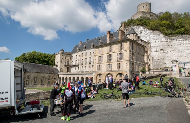
Shortly after we rode into the town of Les Andelys and standing high on the chalk cliffs at the far end of the town was the impressive Château Gaillard, the ruins of Richard the Lionheart’s castle that he built in the late 12th century. I’ve had an interest in castles since I was a child so yet another reason for a more leisurely return to the area.

Chateau Gaillard

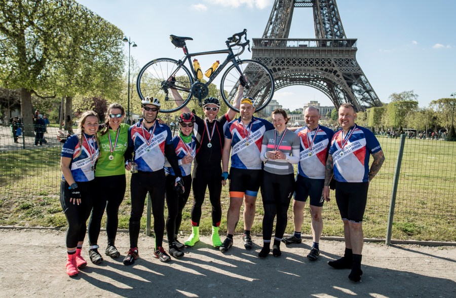
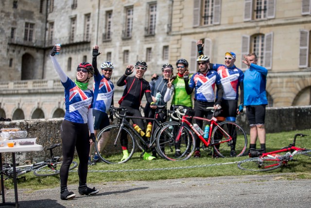
The town of Les Andelys is on the banks of the river Seine and it was here that we stopped for a snack with the chance to offload the now unneeded layers of clothing into our bags and another group photo, this time in our excellent L2P24 jerseys.

London 2 Paris 24hr cycle sportive. Photo credit : Chris Winter
Group photo on the banks of the Seine at Les Andelys – Photo by Chris Winter

What you can’t see in the photo above is the blood running down my left leg, as I arrived at the stop my cleat got caught in the pedal (my excuse and I’m sticking to it as I am sure that I unclipped), with both feet clipped to the pedals and no forward motion theres only one direction left to go… yes I met the ground coming up on my lefthand side, my knee took the brunt of the fall. Now usually the blood of a small cut and graze will clot quite quickly. However, with my heart medication my blood doesn’t clot very easily (and I don’t want it too either) so it was it time to test the first aid supplies and ask for a plaster.

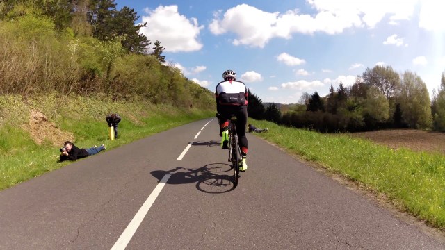
With my knee patched up we left Les Andelys behind us following the meandering river Seine towards Vernon and ultimately Paris. With the quiet country roads we were riding two abreast for most of the way, the traffic was starting to build as we passed through Vernon so we took to a single file train taking turns at the front. I took the opportunity to record a short video of us as I dropped back from my turn at the front.

We stayed in the train all the way to the next snack stop, along the way Chris, Tom and Luke (the event photographers) passed us in the car. A couple of miles down the road I spotted the car parked on the roadside and they had setup on both sides of the road to take photos and video footage. I must say a big thank you to them all for the brilliant photos and memories.

L2P24-00-09-42-619
Chris, Tom and Luke setting up for a shot of the Team Tally Ho train
London 2 Paris 24hr cycle sportive. Photo credit : Chris Winter
The Team Tally Ho train to Paris – Photo by Chris Winter
London 2 Paris 24hr cycle sportive. Photo credit : Chris Winter
Snack stop 3 at La Roche Guyon – Photo by Chris Winter
London 2 Paris 24hr cycle sportive. Photo credit : Chris Winter
Clea taking a Tally Ho group selfie – Photo by Chris Winter

The section between snack stop 3 and lunch, whilst only 21 miles, had the two largest climbs of the day at Sailly and L’Hautil (almost 1200 feet in little under 12 miles), whilst climbing L’Hautil my Garmin clicked over onto 100 miles. By this time I could feel the previous 158 miles in my legs but I made it up both to be rewarded with lunch at Chanteloup Les Vignes.

Clea had completed the last part of the climb and into the lunch stop pedalling with just one leg as her lefthand crank had fallen off, fortunately the event mechanics weren’t far behind us and it wasn’t long until the crank had been reattached. We were on a way for the leg and the run into Paris.

We were getting close to the 24 hours and the traffic lights of the suburbs of Paris were not playing, each one seemed to turn red just as we approached. We crossed the Seine for the final time as a group and cycled under the Eiffel Tower, stopping my Garmin at 4:57pm (French time) – Total time 24 hours 28 minutes and if you allow for the ferry delay it would have been 23 hours 28 minutes.

L2P24-00-11-08-982
Crossing the Seine and arriving at the Eiffel Tower
London 2 Paris 24hr cycle sportive. Photo credit : Chris Winter
Champagne under the Eiffel Tower, Paris – Photo by Chris Winter

Whilst my goal was to cycle under 24 hours, I do not see it as a failure in a way, but a fantastic achievement for someone who has previously suffered a heart attack and couldn’t walk for more than 5 minutes without getting out of breath. If you would have said to me five years ago, as I was lying on my hospital bed on the day of my heart attack, that I would ride to Paris in 24 and a half hours I wouldn’t have believed you. It just goes to show what you can achieve, start off with small steps and see where it takes you, the most important thing is that you start.

So you’ve read about my experience, I hope you enjoyed it and that I’ve inspired you to want to do the same. If so sign up here for the ride of a lifetime and achieve something extraordinary.

It would be great if you could visit my Just Giving page and perhaps give a donation to Pumping Marvellous as we need to raise awareness about Heart Failure and help other heart patients that are not as fortunate as me.

I’ll be on the start line again in Greenwich on Saturday 29th April 2017 – I’ve still got that magic 24 hours to beat 🙂

Hopefully I will see you there and as Sophie says

One Day I Will Not Be Able To Do This, Today Is Not That Day

Celebrating Life – MI +5

If you have read my blog before you will know that, at the age of 38, I suffered a myocardial infarction (MI, better known as a heart attack).  It was caused by a combination of bad habits – a sedentary lifestyle, poor diet, smoking and a general lack of exercise.  That was five years ago and I have come along way since that hospital bed in Scotland, completely turning my life around by taking up cycling and running.

I don’t want anybody to have to go through what I did on the fateful day in April 2011.  Through my involvement with the Ordnance Survey #GetOutside Campaign, I’ve been sharing my story to encourage others to become active, whilst offering hope and inspiration to other heart failure patients that there is a future after such life changing events.

To mark the 5th anniversary of my MI and raise awareness of Heart Failure I’ve set myself a few challenges for April and May: –

#ChampionsWearOrange

I’ll be in my bright orange OS GetOutside kit for all four rides, do please say hello if you see me!

The main event is London to Paris, I leave Greenwich at 4pm on Saturday 30th and need to arrive at the Eiffel Tower before 4pm on the Sunday (70 miles to Newhaven for the four hour night ferry crossing to Dieppe and then 120 miles to Paris).

Paris

Whilst awareness of Heart Disease/Failure and getting people more active is my main driving force, I would like to raise much needed funds for Pumping Marvellous, a heart charity that represents the needs of nearly one million heart failure patients and just as importantly the patients families, at the same time.

If you would like to help the fight against heart failure – 20% of the adult population in the UK will be touched by heart failure and heart disease at sometime in their life – please donate to Pumping Marvellous by visiting my Just Giving page www.justgiving.com/coeurcycliste

Behind the scenes with Ordnance Survey

It’s a practice that has taken place for over a century, people across Great Britain have grabbed Ordnance Survey (OS) maps, unfolded them and then scanned across the beloved grid squares searching out the familiar symbols we all learnt in school – roads, rivers, woods, churches, youth hostels, trig points, train stations, parking, contour lines etc.

All of this detail is vital to help you plan your next adventure and to navigate on the day – Where are you going to park? What feature are you going to take a bearing off? Where might you stop for a spot of lunch?

Ordnance Survey Explorer Map
Ordnance Survey Explorer Map of Great Malvern with the familiar symbols

Have you ever stopped to think about how all this detail gets onto the map in the first place and more importantly how does it get updated?  I spent a day and a half with Dom Turnor, a Surveyor with the OS, finding out how the master map of Great Britain is updated and how often.  I make no apologies for the length of this post as I believe it is deserved given the subject matter and the privileged access given to me by OS.

Dom is one of approximately 250 field surveyors across the country and is responsible for the Malvern District, which is part of the Wales and West Central region.  His district is long and thin from the county borders of Worcestershire and Shropshire in the north, down to Cheltenham in the south, as highlighted in the image below.

Malvern District - Wales and West Central
Malvern District – Wales and West Central showing Land Registry Customer Orders

Due to the size and shape of the District, Dom plans his work into economic packages, saving time, fuel and the environment.  I joined him for this planning on Monday afternoon at his home office where he explained the systems, processes and different types of surveying tasks he undertakes on a daily basis.

You may be surprised to learn that OS make approximately 10,000 changes to the master map every day and aim to capture all major change within 6 months of it happening. Each of these changes start as a field customer order which are generated from numerous sources such as HM Land Registry, Local Councils, Surveyors, OS HQ, third party suppliers etc.  Whilst there are multiple categories for these orders the majority will fall into one of four categories: –

  • Prestige sites – Sporting venues, Large shopping centres.
  • Land Registry – Survey requisitions for boundaries and land access
  • Total Revision – Changes such as construction works, house building
  • Derived Products – The symbols identifying locations and services

The field customer orders are downloaded on a regular basis to the surveyors computer and then “taken-up” to show that a surveyor is assigned to the order. As I would be spending the following day with Dom, he had selected a range of orders from the various categories, with the exception of the Prestige Sites as these are generally complex by nature.  For example the redevelopment of the racecourse in Cheltenham took several full days to survey.

Our customer orders for the following day were: –

  1. Land Registry –  boundary survey between two private properties requested by HM Land Registry so that the deeds to the properties could be updated.
  2. Total Revision – a new Sainsbury’s Local supermarket has recently been built and opened in Malvern.  The store and surrounding area needs to be surveyed and added to the master map.
  3. Land Registry – query over the precise location and boundaries of an electric sub station in Malvern.
  4. Total Revision – several new housing estates and notifications of potential building works in the Malvern area.  These would be initial visits to ascertain the stage of the building works, if any.
  5. Derived Products – a selection of locations and services that we would check were still there as we were passing them.

I met Dom on the Tuesday morning and after a few admin tasks we set off for the first land registry job, as it relates to private property I won’t go into much detail, albeit to say that we met the land owners, surveyed the fence line and boundary identified in the request, along with several photographs from requested viewpoints.

With the land registry job complete, we headed off for the new Sainsbury’s Local in Buttercup Walk, Malvern.

Sainsbury's Local Malvern
New Sainsbury’s Local, 30 Buttercup Walk, Malvern, WR14 1NR

I was surprised and delighted when Dom said that he would let me survey the store! As you can see from the photo above, the store is essentially a rectangular box, with a car park, several fences and landscaped areas.

With the wide open space this is an ideal area to use GPS, the Global Positioning System – a network of satellites in a precise orbit constantly transmitting signals to Earth.  Essentially a GPS receiver compares the time a signal was transmitted by a satellite with the time it is received, it is this time difference between the signals that tells the GPS receiver how far away the satellite is.  Once the receiver picks up more than three signals it can start to triangulate its position, the more satellites it picks up the more precise the location will be. The OS has a beginners guide to GPS if you would like more detail.

Most of us are probably familiar with GPS receivers and have used one in some form or another, with receivers in sat navs, smartphones, activity tracking devices and handheld navigation devices. These devices are generally accurate to within 5 to 10 metres 95% of the time.  Whilst this level of accuracy is sufficient for consumer use, it is not precise enough for detailed mapping. Therefore, each OS Surveyor has a state of the art Leica GS15 GPS receiver, mounted on a 1.8 metre pole and connected to the surveyors laptop via bluetooth and to the cellular phone network.

Surveying with the Panasonic Toughbook computer and Leica GS15 GPS Receiver
Surveying in Malvern with the Panasonic Toughbook laptop and a Leica GS15 GPS Receiver

With the equipment setup and connected Dom handed it over to me, I planted the GPS pole on the first corner of the car park, ensured it was level, waited for it to acquire the satellites (we managed to receive signals from 14 satellites), I watched the accuracy/quality of the signal improve to 0.01 (I believe that means an accuracy of 1cm!) and clicked on measure.  A dot appeared at our location on the map, we moved on to the next corner, waited for the accuracy to be less than 0.10, click another dot, then a line appeared joining the dots, move to the next corner, click, another dot, and so on until we had the complete outline of the car park.  Next came the curved kerbs of the entrance to the car park, selecting the curved line tool I measured several points around the kerbs.  Next up was the fencing and footpaths around the site.  With all the landscaping and ground work complete it was time to survey and plot the buildings location.

To get an accurate location with GPS the receiver needs a clear view of the sky, up until this point we were getting very accurate measurements, as we went closer to the walls of the building the accuracy dropped to an unacceptable level.  Therefore to obtain the locations of each corner, we measured a point along the line of each wall, as close as possible with an acceptable accuracy level.  When you have six of these measurements (two at each of three corners) you can join the survey points with lines (the same as plotting the kerb line of the car park), these lines will intersect at each of the four corners giving you the outline of the building. At this point we had a complete plan of the area made up of multiple polygons on the map.

The next stage is to attribute each of these polygons to define what it actually is, this does not need to be done on site.  As it was approaching midday, we decided on an early working lunch somewhere in the warm.

With a steak and stilton baguette in hand and a warming mug of coffee, we fired up the laptop and started to attribute the polygons we had plotted.  This is where detail is important, for example a path isn’t the same as a pavement (a pavement is on the side of the road, whereas a path goes through an open area), next is the surface sealed or unsealed? likewise a verge can only be used for the side of a public road and not the edge of a car park.  The last attribute to assign is to set the Sainsbury’s building as a functional site (retail) and add the road number to it.  The number on the building must be aligned to the road it is on. The image below shows the final result of our survey.

OS GIS Software - Surveying
OS GIS Software – Surveying and adding Sainsbury’s to the master map

Having eaten and warmed up, with went off in search of the Old Hollow electrical sub station.  The sub station is located up a small dirt track surrounded by tall trees, we attempted to get a GPS location, but as expected the accuracy was out by over three metres due to the trees. Without GPS it was back to the trusty tape measure, line of sight and measuring from other features already plotted on the map.

Old Hollow Electrical Sub Station, Malvern
Old Hollow Electrical Sub Station, a 6.2m square fenced off enclosure in amongst the trees.

Next on our list were several sites that have been marked for new construction works.  There were no signs of any work on any of these three sites. However, this isn’t unusual as planning permission can be granted but the developers do not necessarily start immediately.  Although we did locate two new housing estates being built in Welland. It is important to keep on top of these sites, especially new housing estates as it is quicker and easier to survey a buildings foundation with accurate GPS signals before the walls are built.

Last on the list were several Derived Products, these are the familiar symbols across the map, we didn’t get the opportunity to check many of these as surveying the sub station took longer than expected. A viewpoint, such as the Worcestershire Beacon on top of the Malvern Hills, is extremely unlikely to change.  However, items such as telephone boxes are being decommissioned and removed on a regular basis.  Although most are removed they are also being re-roled for other purposes, such as housing defibrillators or in the case of one in Malvern, a library/book exchange.  Therefore just driving past a telephone box isn’t enough to check that it is still in use.

Having finished the field surveying, we returned to Dom’s house to fill out the paperwork for the land registry surveys, upload our changes to the main OS servers in Southampton and submit the completed field customers orders and paperwork.

I’m now going to be checking the online OS Maps and iPhone OS Maps app daily looking for these changes to appear.  I can now officially say “I’ve put Sainsbury’s on the map”

I can’t thank Dom and the Ordnance Survey enough for showing me a peek behind the scenes, there is so much more detail that I could have added but I wanted to keep it to an overview of the day. I hope that this post gives you an insight into the role of a OS Surveyor and that you found it as informative and enjoyable as I have researching it and writing it.

I am now wishing that I asked to do this for work experience back at school and a pursued a full time career as a Surveyor…


Ordnance Survey #GetOutside Champion

I am excited, proud and amazed to be able to announce that I’ve been chosen as an Ordnance Survey #GetOutside Champion and have this fantastic opportunity to be able to inspire others to get outside and become fit and active.

OS Trig PointA new day, endless possibilities…

… let’s make 2016 a year to remember by getting outside and active.

You can start by making a pledge on the OS website, mine is: –

To mark the 5th year since my Heart Attack, I pledge to cycle to Paris from London in under 24 hours and to run at least a mile every day for the next 366 days – (Dan Grant – 31st October 2015)